Thermal Drone Deer Recovery in Western Wisconsin
Thermal drone deer recovery throughout Western Wisconsin, based in Eau Claire and New Auburn. $350 flat search fee—no additional locate fee. Call or text Dave at 715-210-3506 to discuss your location and availability.
📍Deer Recovery Service Area
Based in Eau Claire and New Auburn, Drone-Search provides thermal drone deer recovery throughout Western Wisconsin, generally within about 60 miles of our locations. We serve Eau Claire, Chippewa, Dunn, Buffalo, Trempealeau, Clark, and Rusk counties.
Drone deer recovery in Rusk County and near New Auburn
Drone deer recovery in Dunn County
Drone deer recovery in Buffalo County

🎯Where Thermal Drone Recovery Helps
Thermal drone searches can help cover large areas such as fields, woods, wetlands, heavy cover, river valleys, and agricultural land more efficiently than ground searching alone.
From the air, we can scan areas where a deer may be difficult to see from the ground.
⚖️Wisconsin Drone Deer Recovery Rules
Wisconsin law prohibits using drones to hunt or pursue wildlife. Drone-Search uses drones only to assist with locating deer believed to be dead and conducts searches with Wisconsin DNR requirements in mind.
Before a search, customers receive a waiver and acknowledgment explaining applicable drone-recovery requirements. Hunters remain responsible for hunting regulations, shooting hours, weapon restrictions, and permission to enter private property.

🔥How Thermal Imaging Helps Locate Deer
Thermal imaging detects differences in surface temperature, helping us identify deer-sized thermal signatures that can be difficult to see from the ground.
When we detect a possible deer, we use the drone's high-resolution camera and up to 200× hybrid zoom to examine the area more closely.
Thermal cameras cannot see through solid tree trunks, branches, or leaves. However, by changing the drone's altitude and viewing angle, we can often detect small areas of exposed body heat through openings in the tree canopy. Weather, vegetation, terrain, sunlight, and air temperature can all affect thermal visibility.

How Thermal Drones Work
Watch how Drone-Search uses aerial thermal imaging to locate deer and help determine whether an animal is deceased or still alive. Thermal imaging combined with high-resolution aerial cameras can provide hunters with valuable information for making responsible recovery decisions.
Real Thermal Drone Deer Recovery Missions
Cranberry Marsh Buck — Located by Thermal Drone Near Warrens, WI
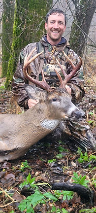
A hunter near Warrens, Wisconsin contacted Drone-Search after making what he believed was a good hit on this buck. The surrounding cranberry marsh, swamp, and lowland terrain included waist-deep water in places, making a conventional ground search extremely difficult. Using thermal imaging from the air, we located the buck and provided its precise GPS location. The hunter was then able to identify a dry route into the area and successfully recover his deer.
Lake Hallie Buck — Located by Thermal Drone in Tall Grass
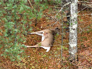
A hunter near Lake Hallie, Wisconsin had already searched this field on foot without locating her buck. Using thermal imaging from the air, Drone-Search located the deer concealed in tall grass and sent the hunter its precise GPS location using a QR code. In the video, you can watch her follow the map on her phone and walk directly to the deer—demonstrating how aerial thermal imaging and precise GPS coordinates can help locate an animal that may be difficult to see from ground level.
🚁How the Process Works

1. Call or Text Drone-Search
We ask whether you believe the deer is deceased and have you text us a GPS pin for the search location. When we're en route, we'll provide an estimated arrival time.
2. We Review the Shot and Tracking Information
Before launching, Dave asks where the deer was hit, how it reacted, its direction of travel, blood-trail details, and where you believe it may have gone.
3. We Conduct the Thermal Drone Search
We search from the air for deer-sized thermal signatures and use the drone's high-resolution camera and zoom to examine possible targets more closely.
4. If the Deer Is Found Deceased
We provide precise GPS coordinates and a photo to help guide you to the deer. Thermal and optical video of the located animal can also be provided.
5. If the Deer Is Found Alive
We discontinue the recovery search and do not disclose the deer's location. We can show you photos or video and discuss what we observed. If we believe the deer may expire, Drone-Search may return the following day at no additional charge to attempt to relocate and reassess it.
⏱️When to Call for a Thermal Drone Search
Consider calling Drone-Search when:
• You've lost the blood trail
• Rain or weather has erased tracking signs
• The deer entered dense cover, wetlands, or difficult terrain
• Ground visibility is poor
• You need to search a large area efficiently
• You're unsure whether the deer has expired or is still alive
If you're uncertain about the deer's condition, call or text Dave before continuing an extensive ground search. The shot information, deer's reaction, blood evidence, and direction of travel can help us plan the aerial search.


Frequently asked questions