



Thermal Drone Deer Recovery & Search in Buffalo County, Wisconsin
🦌
Shot a deer in Buffalo County and lost the blood trail? Drone-Search uses thermal imaging and high-resolution aerial cameras to search steep wooded bluffs, ravines, creek bottoms and farmland.
We help hunters on rural properties around Alma, Mondovi, Buffalo City, Fountain City, Cochrane, Nelson and surrounding areas. Dave Whitehouse brings more than 35 years of Search & Rescue experience to planning searches around the shot location, direction of travel, last blood and terrain.
The search costs $350, with no additional locate fee. Call or text Dave at 715-210-3506 with your location to discuss availability. Response depends on weather, flight conditions and existing search commitments.
Searches focus on deer believed to be deceased. If we locate a deer alive, we discontinue the recovery search and may return to confirm it is deceased.
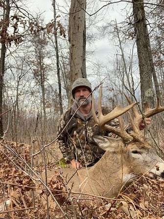
When It's the Buck of a Lifetime
A trophy whitetail can represent years of scouting, trail-camera history, habitat work, and time in the woods. After the shot, uncertainty about where that deer went—or whether it is still alive—can make the recovery decision especially difficult.
Drone-Search uses aerial thermal imaging together with high-resolution optical and 200× Hybrid Zoom capabilities to search for the deer from the air. When a deer is located, thermal and visual imagery can help determine whether it is deceased or still alive and provide information that can guide the next responsible step.
If we locate the deer alive, we discontinue the recovery search and do not disclose its location. We can show the hunter photo or video evidence and discuss what we can observe about the deer's condition. When circumstances indicate the deer may expire, we may return the following day at no additional charge to attempt to relocate and reassess it.
🐾 Why Thermal Drone Recovery Fits Buffalo County's Bluff Country
-
Buffalo County's Driftless landscape includes steep wooded bluffs, ridges, ravines, creek bottoms, agricultural fields, and thick cover. A wounded deer can travel into terrain that is difficult, slow, or exhausting to search thoroughly from the ground.
-
A thermal drone provides a different perspective. From the air, we can systematically search large areas and change altitude, position, and viewing angle to investigate likely travel routes, bedding areas, field edges, ravines, and other locations where a deer may be found.
-
Thermal imaging cannot see through solid trees, leaves, or branches, but even small openings in vegetation can expose portions of a deer's heat signature. Changing viewing angles can be especially valuable when searching wooded bluff terrain.
-
📍 A 94% Deer Location Rate During the 2025 Season
During the 2025 deer season, Drone-Search located deer in 94% of the deer searches we conducted. This is a location rate, not a recovery rate—some of the deer we locate are still alive. In those situations, the thermal drone can provide valuable information without sending hunters or a tracking dog toward the animal.
When a deer is located, we can record thermal imagery and high-resolution aerial video to help document what we found. For deceased deer, we can provide a precise GPS location to help guide the hunter to the recovery site. For live deer, photo and video evidence can help the hunter better understand the animal's condition while we follow our procedures for live-animal encounters.
🚁 Before You Push a Wounded Buck, Consider the Next Step
After an uncertain shot, immediately pushing into thick cover can sometimes move a wounded deer farther from the original area and make the situation more difficult to evaluate. Before beginning an extensive ground search, call Drone-Search and tell us what happened—including the shot location, direction of travel, deer reaction, last-known location, blood sign, and any tracking already completed.
A thermal drone search can cover likely travel areas from the air with minimal ground disturbance. If the deer is located, thermal and zoom imagery may help determine whether it is deceased or still alive before the hunter decides what to do next.
If you have photos or video of the shot, trail-camera images, or a mapped location, that information can also help us plan the search.
📞 Buffalo County Deer Recovery — $350 Flat Fee
Drone-Search charges a flat $350 fee for a thermal drone deer search. There is no additional locate fee if we find your deer.
If we locate the deer alive and observations suggest it may expire, Dave may return the following day at no additional charge to attempt to relocate the deer and reassess its condition.
Searches can range from relatively quick locations to difficult missions requiring two hours or more of flight and search time on-site. The goal is not simply to put the drone in the air—it is to conduct a systematic search based on the available evidence, terrain, and conditions.
Search Steep Terrain Without Sending People Into Every Ravine
Buffalo County's steep slopes, wooded ravines, creek bottoms, and thick cover can make a traditional ground search physically demanding and time-consuming. A thermal drone can examine many of these areas from lawful airspace without requiring a hunter or tracking team to physically enter every part of the property.
The drone can also search across neighboring property from lawful airspace when appropriate, although hunters must still obtain permission before physically entering another person's property to retrieve a deer. This can help gather useful information about where a deer traveled before unnecessary ground searching occurs.
🔗 Thermal Drone Deer Recovery Throughout Buffalo County
Drone-Search responds to deer recovery searches throughout Buffalo County, including Alma, Mondovi, Buffalo City, Fountain City, Cochrane, Nelson, and surrounding rural areas. We also serve hunters on farms, hunting properties, wooded acreage, and other locations throughout the county's bluff country.
If you've shot a deer in Buffalo County and are uncertain about the next step, call or text Drone-Search. The sooner we understand the shot, tracking history, terrain, and last-known location, the better we can evaluate the situation and plan an effective thermal drone search.
Experienced Search & Rescue Approach to Deer Recovery
Drone-Search owner and pilot Dave Whitehouse is a retired Eau Claire Fire Department Captain with more than 35 years of Search & Rescue experience and is an FAA Part 107-certified remote pilot. He is also a lifelong Wisconsin hunter who understands the importance of making a responsible recovery effort after the shot.
Each deer search combines that search experience with aerial thermal imaging, high-resolution cameras, terrain analysis, and systematic search patterns. The search can change as new information develops—whether that's a heat signature, tracks, blood information, terrain features, or observations made from the air.
Explore Our Services and Service Areas
Buffalo County Deer Recovery FAQ
Can you use a thermal drone to find a deer in Buffalo County's steep bluff terrain?
Yes. Drone-Search uses aerial thermal imaging and high-resolution cameras to search steep slopes, wooded ridges, ravines, creek bottoms, fields, and other difficult terrain found throughout Buffalo County. Thermal imaging cannot see through solid trees, leaves, or branches, but changing the drone's altitude, position, and viewing angle can reveal exposed portions of a deer's heat signature through openings in vegetation.
What happens if the trophy buck is still alive when you find it?
If Drone-Search locates the deer alive, we discontinue the recovery search and do not disclose the deer's location. We can show the hunter thermal or visual photo and video evidence and discuss what we can observe about the animal's condition. If the deer appears likely to expire, Dave may return the following day at no additional charge to attempt to relocate the deer and reassess its condition.
How much does a thermal drone deer recovery search cost in Buffalo County?
Drone-Search charges a flat $350 fee for a thermal drone deer search in Buffalo County. There is no additional locate fee if we find your deer. The search may include thermal imagery, high-resolution aerial video, and precise GPS information when appropriate. If a deer is located alive and appears likely to expire, Dave may return the following day at no additional charge to attempt to relocate and reassess it.
Can you search neighboring property, and do I need permission to retrieve my deer?
A drone may be able to search neighboring property from lawful airspace without a hunter, dog, or handler physically entering the property. This can be especially useful in Buffalo County's bluff country when a deer crosses property boundaries. Hunters are still responsible for obtaining permission before physically entering another person's property to retrieve a deer. Flight operations remain subject to applicable airspace and operating requirements.
How soon after the shot should I call for a thermal drone search?
You can call Drone-Search as soon as you become uncertain about the shot or recovery. Before continuing an extensive ground search, tell us the shot location, direction of travel, deer reaction, last-known location, blood sign, and any tracking already completed. Dave can use that information along with the terrain and conditions to help plan the search. Thermal searches can also remain useful well after the initial shot; Drone-Search has detected deer thermal signatures more than 48 hours after death and has located deer as long as five days later.
Can thermal imaging find a deer in Buffalo County's woods and heavy cover?
It can, depending on the vegetation and viewing angle. Thermal cameras do not see through solid trees, leaves, branches, or other objects. However, even small openings in the canopy or vegetation can expose portions of a deer's heat signature. By changing altitude, position, and viewing angle, Drone-Search can examine wooded slopes, ravines, field edges, and other cover from multiple perspectives. Dense vegetation can still limit detection, so no thermal search can guarantee a locate.
Will a thermal drone search disturb or push a wounded deer?
Aerial thermal searching can help gather information while minimizing unnecessary ground disturbance. Rather than immediately sending people or a tracking dog through the area, Drone-Search can observe likely travel routes, bedding areas, fields, ridges, and other terrain from the air. In Dave's field experience, the drone has allowed live deer to be observed without sending people or a dog toward them. If a live deer is located, Drone-Search discontinues the recovery search and follows its live-deer procedure.